Skip to main content
Home
Explore
Explore
Author Profiles
Selkirk Innovates
About
FAQs
Guidelines
Copyright
Formats & Sizes
File Naming
Submit Content
Submission Agreement
Contact
Search terms
Select Collection
All Top Level Collections
FWW Students
Student Work
King Collection
Selkirk Innovates
Harry Pepper Fonds
Additional Manuscripts Fonds
Selkirk College Collection
Mason Collection
SEG Faculty
HHS Students
Pictin/Scott Slide Collection
Faculty Publications
Selkirk College Archives
Archival Maps and Plans
UAS Students
SEG Students
School of Environment & Geomatics
HHS Faculty
School of Health & Human Services
Local Newspapers
Arca Appearance
Minto Files
UAS Faculty
Selkirk College Fonds
Industry & Trades
Photographs
Archival Photographs
Mir Website Archive
Mir Centre for Peace Collection
Artifacts
Selkirk College Documents
University Arts & Sciences
Doukhobor Collection
Migration stub
Selkirk College Calendars
DANM Students
Local Indigenous Collection
Black Bear Review
Search
DGI Header Menu
Home
Explore
About
Contact
Columbia Basin Watershed Network
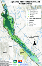
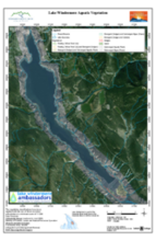
Lake Windermere Ambassadors
Slocan River Streamkeepers
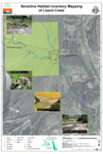
Liard Creek
Wildsight (Association) Golden
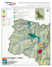
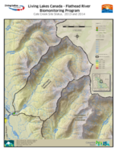
Living Lakes Canada - Flathead River Biomonitoring Program: 2017 Status
Glade Watershed
Columbia-Shushwap Invasive Species Society
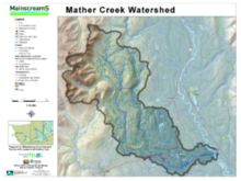
Mather Creek (Mainstreems)
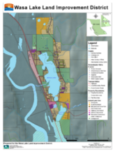
Wasa Lake
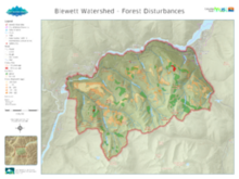
Blewett (Blewett Watershed Group)
Flathead River Biomonitoring Program (Living Lakes Canada)
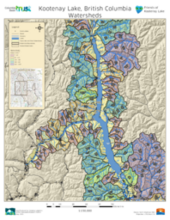
Kootenay Lake (Friends of Kootenay Lake)
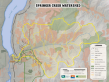
Springer Creek (Springer Creek Restoration & Preservation Alliance)
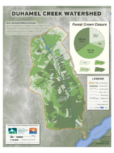
Duhamel Creek (Duhamel Watershed Society)
East Shore (East Shore Freshwater Habitat Society)
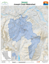
Mainstreams/Joseph Creek
Lake Windermere Ambassadors
Friends of the Lardeau River GIS & Mapping Support Project
Elk River Alliance
Salmo River (Salmo Streamskeepers Society)
Pagination
First page
« First
Previous page
‹‹
Page
1
Page
2
Page
3
Page
4
Page
5
Page
6
Page
7
Current page
8
Page
9
Next page
››
Last page
Last »