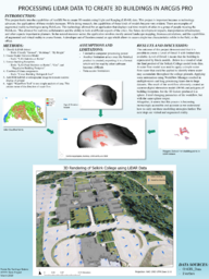
This project looks into the capabilities of ArcGIS Pro to create 3D models using Light and Ranging (LiDAR) data. This project is important because as technology advances, the applications of these models increases. While doing research, the capabilities of these kinds of models became very evident. There are examples of augmented reality technologies using HoloLens. This technology allowed for an application that displays real time models of cities to a group of people wearing the HoloLens. This allowed for real time collaboration and the ability to look at different aspects of the cities, like future development impacts, transportation infrastructure, and other aspects important to planners. In the natural resource sector, the application revolves mostly around landscape mapping, biomass calculation, and the capabilities of augmented and virtual reality to assess forests. A developer out of Sweden created an app which allows to access single tree characteristics while in the field, or the office.