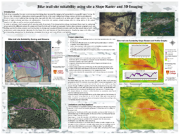
Trail riding is arguably the most common mountain biking style because the category isn’t grounded in any specific type of racing. It's for any rider interested in riding solo or meeting up with friends at the local trailhead and riding a mixture of climbs and descents. There is more to trail building than moving rocks, logs and dirt. Bike trails usually end up being part of larger systems that are the result of highly technical planning and collaboration. These bike trail systems should comply with the riding ability of the widest spectrum of riders as well as environmental guidelines. In order to achieve a trail network which complies with all or most of the characteristics above mentioned there must be a planning phase where the different options for where and how the trails will be built are analyzed. Cutting edge computer programs such are ArcMap and ArcPro allow planners and trail builders to display and visualize different elements and how they would interact with the environment and make smarter decisions for the future form and function of the whole network. Visualizing maps in 3D offers new and interesting perspectives for developing a strategies for smarter and more efficient trail building